Tag Archives: Matthew

Day 10: Matthew 27-28

Finally, we get to the crucifixion and resurrection of Jesus. These are the chapters upon which our entire faith is based.

CHAPTER 27

This chapter is the second chapter in the book that only contains the words of Jesus and nothing else. This happened two days before his arrest.

  • Read Matthew 27:1-31.
      • Verse 1 – Notice the different locations.
      • Map 20 - Gethsemane to Calvary

        (Click on map to enlarge) – This gives you the likely locations of Jesus’ trials, death, and resurrection. It shows the path from Gethsemane to his trial before the religious leaders at the Palatial Mansion [salmon color], mentioned in chapter 26. From there he is taken to see Pilate (27:1-2) [blue]. He is then taken to see Herod (not told in Matthew’s Gospel) [white], then back to Pilate [yellow]. Finally he walks to the place of crucifixion [green].

      • Verse 2 – Notice the Citadel.
      • Photo 73 - Citadel

        (Click on photo to enlarge) – This is David’s Citadel – which is where Pilate would have met with Jesus.

      • Verse 29 – Notice the crown of thorns.
      • Photo 74 - Crown of Thorns

        (Click on photo to enlarge) – This is a crown of thorns made from branches of a common thorn bush found in Israel.

  • Read Matthew 27:32-56.
      • Verse 32 – Notice the Church of the Holy Sepulcher.
      • Photo 67 - Church of Holy Sepulcher

        (Click on photo to enlarge) – The two round domes you see in the middle of the photo is the Church of the Holy Sepulcher. This is the most likely location of Jesus’ death and resurrection. It isn’t popular with evangelicals because it is now a large church building and is used by six different churches.

      • Notice the next 4 photos of the Church of the Holy Sepulcher.
      • Photo 68 - Church of the Holy Sepulcher
          Photo 69 - Church of the Holy Speulcher
            Photo 70 - Church of the Holy Sepulcher
              Photo 75 - Crucifixion Location

              (Click on photos to enlarge) – These photos give you an idea of what it is like inside the church. We will spend some time in and around the church explaining its location and why we believe it is the location of the death and resurrection of Jesus.

            • Verse 32 – Notice the inside of the Church of the Holy Sepulcher.
            • Photo 62 - Church of Holy Sepulcher

              (Click on photo to enlarge) – This shows you a drawing of the inside of the Church of the Holy Sepulcher. Notice the larger dome on the left. Then notice the building built inside the dome. That is the location traditionally celebrated as the tomb of Jesus.

            • Verse 33 – Notice the Place of the Skull.
            • Photo 71 - Place of the Skull

              (Click on photo to enlarge) – This is an alternative location for the crucifixion of Jesus. As you look at the face of the rock, you might see why some suggest they called this “the Place of the Skull.” Most evangelicals want this to be the place – as it is more natural (no church built over it) and therefore more serene and worshipful for us. Yet there is no real evidence beyond the fact that the cliff face looks like a skull.

        • Read Matthew 27:57-66.
            • Verse 57 – Notice the Garden Tomb.
            • Photo 72 - The Garden Tomb

              (Click on photo to enlarge) – This is the Garden Tomb and is an unlikely alternative location for the resurrection of Jesus. It is peaceful, worshipful, and enjoyable to visit – as it gives us a reminder of what the surroundings may have been like. We will talk about why this is the desired yet unlikely location of the resurrection of Jesus.

            • Verse 61 – Notice the tomb.
            • Photo 63 - Tomb

              (Click on photo to enlarge) – This is inside the Church of the Holy Sepulcher. That building under the dome is the likely place of the resurrection of Jesus.

            • Verse 62 – Notice the other tombs.
            • Photo 64 - Tombs

              (Click on photo to enlarge) – Notice the small room on the left side of the drawing. This is my favorite place in the church. There are six first century tombs here. This will give you the best understanding of the location where Jesus was buried.

          CHAPTER 28

          This chapter is the basis of our faith – the resurrection of Jesus. Rather than any more photos or maps – just read and enjoy the story.

        • Read Matthew 28:1-20.


        • Day 9: Matthew 25-26

          These two chapters begin with more parables and end with Jesus’ arrest and trial. We are in the final hours of Jesus’ life. As you read, remember the price he paid for your forgiveness and freedom.

          CHAPTER 25

          This chapter is the second chapter in the book that only contains the words of Jesus and nothing else. This happened two days before his arrest.

        • Read Matthew 25:1-46.
            • Verse 32 – Notice the sheep and goats.
            • Photo 56 - Sheep and Goats

              (Click on photo to enlarge) – Both sheep and goats usually made up the flocks of the Shepherds in Jesus’ day. This would be a very familiar image.

          CHAPTER 26

          This chapter contains the last supper, the arrest and the trials of Jesus.

        • Read Matthew 26:1-16.
            • Verse 6 – Notice Bethany.
            • Photo 57 - Bethany

              (Click on photo to enlarge) – This is a picture of the town of Bethany. It was the place Jesus commonly stayed when visiting Jerusalem.

            • Verse 6 – Notice where Bethany is from Jerusalem.
            • Map 18 - Jerusalem

              (Click on photo to enlarge) – This gives you an idea of where Bethany is compared to Jerusalem.

        • Read Matthew 26:17-35.
            • Verse 17 – Notice the path taken.
            • Map 19 - Last Supper

              (Click on map to enlarge) – This gives you an idea of the path from Bethany to the last supper (the traditional location) and then to the Garden of Gethsemane.

            • Verse 30 – Notice the Mount of Olives.
            • Photo 52 - Mount of Olives

              (Click on map to enlarge) – This is the Mount of Olives (more like a hill). The Garden of Gethsemane is located at the bottom of the mount.

        • Read Matthew 26:36-56.
            • Verse 36 – Notice the Olive Tree.
            • Photo 59 - Olive Tree

              (Click on photo to enlarge) – This is an old olive tree in the Garden of Gethsemane.

            • Verse 36 – Notice the Garden of Gethsemane.
            • Photo 60 - Garden of Gethsemane

              (Click on photo to enlarge) – This is the traditional Garden of Gethsemane that has been turned into a tourist site with pathways and flowers.

        • Read Matthew 26:57-75.
            • Verse 57 – Notice the steps to Caiaphas’ house.
            • Photo 61 - Steps to Caiaphas House

              (Click on photo to enlarge) – If the traditional place of the house of Caiaphas is correct, these would have been the steps (street actually) that Jesus walked up toward the house of Caiaphas.

            • Verse 57 – Notice the cell.
            • Photo 58 - Caiaphas

              (Click on photo to enlarge) – This is a cell in the basement of the house of Caiaphas. Perhaps it was here that Jesus was held the night before his death.


        • Day 8: Matthew 22-24

          These three chapters contain a lot of conflict between Jesus and the religious leaders, and it isn’t surprising that they didn’t like him.

          CHAPTER 22

          The tension is building between Jesus and all the different religious leaders in Jerusalem.

        • Read Matthew 22:1-46.
            • Notice Jerusalem.
            • Photo 33 - Jerusalem 1st Century

              (Click on photo to enlarge) – This is an artist’s idea of what Jerusalem would have looked like in the first century. Many of the moments in Matthew 22 probably happened in and around the Temple Mount area.

            • Notice the Temple.
            • Photo 48 - SW Temple

              (Click on photo to enlarge) – This is a photo of the Temple Mount today. The corner you see is the southwest corner of the Temple. The lowest stones are from Jesus’ day. The upper stones were replaced as the temple was destroyed in 70 AD.

          CHAPTER 23

          This chapter contains some of the harshest words Jesus ever spoke. Imagine being there and hearing Jesus say such words to your spiritual and religious leaders.

        • Read Matthew 23:1-4.
            • Verse 2 – Notice the synagogue.
            • Photo 49 - Synogogue

              (Click on photo to enlarge) – This is an artist’s idea of what a synagogue would look like.

            • Verse 2 – Notice the chair.
            • Photo 50 - Synogogue

              (Click on photo to enlarge) – The seat in this photo is called “The seat of Moses.”

        • Read Matthew 23:5-39.
            • Verse 5 – Notice the phylactery.
            • Photo 51 - Phylacteries

              (Click on photo to enlarge) – This is a phylactery, which is worn by orthodox Jews as they take the Old Testament command literally to tie the command on their hands. You will see a lot of this in Jerusalem next month.

          CHAPTER 24

          This chapter begins the last week of Jesus’ life.

        • Read Matthew 24:1-2.
            • Verse 2 – Notice the Western Wall.
            • Photo 53 - Western Wall

              (Click on photo to enlarge) – Notice the pile of rocks at the bottom of the wall. Those were left there to remember the destruction of this temple – which Jesus predicted in verse 2.

            • Verse 2 – Notice the street.
            • Photo 54 - Street

              (Click on photo to enlarge) – This is another view of the temple wall and a first century street upon which Jesus would have walked.

            • Verse 2 – Notice the stone.
            • Photo 55 - Trumpeting Stone

              (Click on photo to enlarge) – This is the “trumpeter’s stone.” There is an inscription on it that says, “to the place of trumpeting.” This is likely the top corner piece of the Temple – which was destroyed in 70 AD.

        • Read Matthew 24:3-51.
            • Verse 3 – Notice the Mount of Olives.
            • Photo 52 - Mount of Olives

              (Click on photo to enlarge) – This is a view of the Mount of Olives from the Temple area.


        • Day 7: Matthew 19-21

          This is day seven of your reading. Jesus starts toward Jerusalem at the beginning of chapter 19 and arrives in Jerusalem at the beginning of chapter 21.

          CHAPTER 19

          This chapter contains one of my favorite stories – where Peter proclaims Jesus to be the Messiah. We will be at that location next month.

        • Read Matthew 19:1-12.
            • Notice Israel.
            • Map 12 - Israel

              (Click on map to enlarge) – Follow the path of Jesus leaving the Capernaum area (Galilee) and traveling on the eastern side of the Jordan River until he arrives across from Jericho. This is the likely location of chapter 19.

            • Notice the Jordan River.
            • Photo 38 - Jordan River

              (Click on photo to enlarge) – This is a modern photo of the Jordan River. You can see why traveling the Jordan Rift Valley (seen in map 12) was a common way to go between Galilee and Jerusalem because of the valley between the mountains. In Jesus’ day, the river was substantially larger than it is now. Much of the river has been diverted for agricultural purposes by Israel.

        • Read Matthew 19:13-30.
            • Notice the camel.
            • Photo 39 - Camel

              (Click on photo to enlarge) – This would be a very common thing to see in Jesus’ day, and probably was nearby when Jesus made his famous statement in verse 24.

          CHAPTER 20

          This chapter begins with a parable and ends with Jesus moving closer to Jerusalem.

        • Read Matthew 20:1-19.
            • Notice the town.
            • Map 06

              (Click on map to enlarge) – This is the likely town Jesus was based in on the other side of the Jordan River, and we know he went through Jericho on this way to Jerusalem. You can see the Dead Sea at the bottom of the map.

        • Read Matthew 20:20-34.
            • Notice Jericho.
            • Photo 42 - Jericho

              (Click on photo to enlarge) – This is a photo looking at Jericho from the north. So the Jordan River would be off of the photo to the left, and the mountains are the way to Jerusalem.

            • Notice the wilderness.
            • Photo 43 - Wilderness

              (Click on photo to enlarge) – This is the terrain and conditions between Jerusalem and Jericho.

            • Notice Jericho Road in the two pictures below.
            • Photo 40 - Jericho Road
                Photo 41 - Jericho Road

                (Click on photos to enlarge) – These are two photos of the old Jericho Road that Jesus would have travelled on the way to Jerusalem.

            CHAPTER 21

            This chapter begins the last week of Jesus’ life.

          • Read Matthew 21:1-11.
              • Verse 1 – Notice Bethphage.
              • Photo 44 - Bethphage

                (Click on photo to enlarge) – This is a photo of Bethphage. It is taken from the Mount of Olives. The photographer is away from Jerusalem.

              • Verse 8 – Notice the route.
              • Map 18 - Jerusalem

                (Click on map to enlarge) – This is the likely route in verse 8-17.

              • Verse 10 – Notice the Eastern Gate.
              • Photo 45 - Eastern Gate

                (Click on map to enlarge) – If Jesus entered Jerusalem on the eastern side (which is the most common view), this is the gate he would have entered.

          • Read Matthew 21:12-46.
              • Verse 12 – Notice Jerusalem.
              • Photo 46 - Jerusalem

                (Click on photo to enlarge) – This is a view of Jerusalem from the Mount of Olives. The wall you see is the wall of the city and just inside of it is the Temple Mount – where Jesus spent time in the last week of his life.

              • Verse 12 – Notice the Temple.
              • Photo 47 - Temple

                (Click on photo to enlarge) – This is an artist’s drawing of the Temple at the time of Jesus.


          • Day 6: Matthew 16-18

            This is day six of your reading. It is the final time Jesus will be in the region of Galilee until after his resurrection. Many of these stories will be very familiar.

            CHAPTER 16

            This chapter contains one of my favorite stories – where Peter proclaims Jesus to be the Messiah. We will be at that location next month.

          • Read Matthew 16:1-13.
              • Notice Caesarea Philippi.
              • Map 17 - Israel Map

                (Click on map to enlarge) – You can see where Caesarea Philippi is.

              • Notice the cave.
              • Photo 31 - Caesaria Philippi

                (Click on photo to enlarge) – This shows the “gates of hell” in Caesarea Philippi.

              • Notice Caesaria Philippi.
              • Photo 32 - Caesaria Philippi

                (Click on photo to enlarge) – This is an artist rendition of what it may have looked like in the days of Jesus.

          • Read Matthew 16:14-28.
              • Notice the path from Capernaum.
              • Map 17 - Israel Map

                (Click on map to enlarge) – Jesus will be travelling down to Jerusalem from Capernaum, and in this section he tells his disciples what will happen on this trip.

            CHAPTER 17

            This chapter contains four different stories – most of which are not as famous as other stories in the book of Matthew.

          • Read Matthew 17:1-13.
              • Notice Mount Herman.
              • Photo 34 - Mt. Herman

                (Click on photo to enlarge) – This is Mt. Hermon. It is commonly believed that this is the location where this story took place.

          • Read Matthew 17:14-21.
              • Notice Mount Herman’s location.
              • Map 17 - Israel Map

                (Click on map to enlarge) – This gives you a concept of where Mt. Hermon is (from vv. 1-13) and where vv. 14-20 took place.

          • Read Matthew 17:22-27.
              • Notice the Coins.
              • Photo 35 - Coins

                (Click on photo to enlarge) – These are ancient coins. Some of these coins are very common in souvenir shops in Israel.

              • Notice Capernaum.
              • Photo 37 - Capernaum

                (Click on photo to enlarge) – Can you imagine Peter catching this fish mentioned in verse 27? This photo is from the shore of Capernaum. Perhaps it was near here that Peter caught his fish.

            CHAPTER 18

            This is another well-known chapter with a couple of very familiar stories.

          • Read Matthew 18:1-6.
              • Notice the mill stone.
              • Photo 36 - Mill Stone

                (Click on photo to enlarge) – The round stone is used for pressing olives. This is what Jesus spoke of in verse 6. Can you imagine one of those hung around your neck and being thrown into the middle of the Sea of Galilee?

          • Read Matthew 18:735.


          • Day 5: Matthew 13-15

            This is day five of your reading. These are three great chapters with a lot of geographical movement and well-known stories. Hopefully the photos and maps will be helpful to give you an understanding of where Jesus went.

            CHAPTER 13

            This chapter contains several well-known parables of Jesus. Next month we will be at the locations where this chapter took place.

          • Read Matthew 13:1-2.
              • Notice the cove.
              • Photo 06 - Sermon on Mount

                (Click on photo to enlarge) – This is the “Cove of the Sower” where we believe this happened. The acoustical properties would allow someone far away to hear someone clearly speaking by the water.

              • Notice the place where Jesus gave the Sermon on the Mount.
              • Photo 09 - Sermon on the Mount

                (Click on photo to enlarge) – This is a view of the hill from the cove.

              • Notice the cove from a different vantage point.
              • Photo 25 - Cove

                (Click on photo to enlarge) – This is a view of the cove from the top of the hill.

              • Notice the hill.
              • Photo 26 - Cove

                (Click on photo to enlarge) – This is a view from the shore of the cove.

          • Read Matthew 13:3.
              • Notice some settings for Jesus’ parables.
              • Photo 23 - Sower
                  Photo 24 - Sower
                    Photo 27- Sower a

                    (Click on photo to enlarge) – The setting of many of Jesus’ parables was vineyards and farmland. These illustrations were very familiar to all the people of the region. This parable is of a sower sowing seeds – which was done through throwing them in the air and letting them fall to the ground. As you read the next section – keep referring to this last picture. It may help the story make more sense.

              • Read Matthew 13:4-23.
                  • Notice the different soils.
                  • Photo 27- Sower a

                    (Click on photo to enlarge)

              • Read Matthew 13:24-35.


              • Read Matthew 13:36.
                  • Notice the home.
                  • Photo 28 - Capernaum

                    (Click on photo to enlarge) – This is a photo of some houses from Capernaum. They made houses from Basalt stones – which help keep the home cool in the summer and warm in the winter.

              • Read Matthew 13:37-52.


              • Read Matthew 13:53-58.
                  • Notice the synagogue.
                  • Photo 17 - Capernaum Synogogue

                    (Click on photo to enlarge) – This is the synagogue from Capernaum that was built on top of the foundation of the synagogue in which Jesus taught.

                CHAPTER 14

                This chapter contains two of the most famous stories of the life of Jesus: Feeding the 5000 and Jesus walking on the water.

              • Read Matthew 14:1-12.
                  • Notice the Marcherus Palace.
                  • Photo 30 - Macherus Palace

                    (Click on photo to enlarge) – This is Herod’s Palace on the east side of the Dead Sea where we believe this story took place.

              • Read Matthew 14:13.
                  • Notice Bethsaida.
                  • Map 11 - Sea of Galilee Towns

                    (Click on map to enlarge) – From the book of Mark, we know Jesus went to the region of Bethsaida.

                  • Notice the plain of Bethsaida.
                  • Photo 29 - Plain of Bethsaida

                    (Click on photo to enlarge) – This is a photo of the plains of Bethsaida. You can see the Sea of Galilee in the distance.

              • Read Matthew 14:14-36.
                  • Notice the different locations.
                  • Map 14 - Matthew 14

                    (Click on map to enlarge) – This gives you a concept of the locations of Matthew 14.

                CHAPTER 15

                This chapter shares a conflict with the Pharisees that came from Jerusalem. It also is about the faith of a Gentile and another miraculous feeding.

              • Read Matthew 15:1-2.
                  • Notice the distance the Pharisees traveled.
                  • Map 12 - Israel

                    (Click on map to enlarge) – This shows how far the Pharisees and teachers of the law travelled to ask Jesus such a seemingly unimportant question. There is more than one route you can take. The most direct route – through Samaria – would be about 90 miles. But these religious leaders certainly wouldn’t have taken that route – since Jews and Samaritans hated each other. So it likely was a route of 120 miles or so – just to ask this question (of course, they had a larger motive).

              • Read Matthew 15:3-20.
                  • Notice Jesus’ travels.
                  • Map 15 - Matthew 15

                    (Click on map to enlarge) – Look at this picture as you read the rest of the chapter to visualize Jesus’ travels through this chapter.

              • Read Matthew 15:21.
                  • Notice Tyre and Sidon.
                  • Map 13 - Tyre and Sidon

                    (Click on map to enlarge) – Notice where Tyre and Sidon are. Remember, this is outside of the national borders of Israel. That will make sense as you read the next story.

              • Read Matthew 15:22-28.


              • Read Matthew 15:29-39.
                  • Notice Tyre and Sidon again.
                  • Map 13 - Tyre and Sidon

                    (Click on map to enlarge) – Remember, this is outside of the national borders of Israel.

                  • Notice the different routes.
                  • Map 16 - Matthew 15

                    (Click on map to enlarge) – We know from verse 39 that Jesus heads to Magadan. We also know from Mark he ends up back at Bethsaida. So this is his likely route.


              • Day 4: Matthew 10-12

                This is day four of your reading. I’m open to any and all feedback. Is this helpful to give you a “lay of the land”? If you have any thoughts or suggestions, please pass them on to me.

                Chapter 10

              • Read Matthew 10:1-4.
                  • Notice Capernaum today.
                  • Photo 19 - Capernaum

                    (Click on photo to enlarge) – This is modern day Capernaum.

                  • Notice Capernaum in Jesus’ day.
                  • Photo 20 - Capernaum

                    (Click on photo to enlarge) – This is an artist rendering of Capernaum in Jesus’ day. It wasn’t a major city. We don’t know how many people lived there, but it was enough to have a synagogue. Perhaps somewhere between 1000 and 5000 people lived in Capernaum.

              • Read Matthew 10:5-42.

                Chapter 11

              • Read Matthew 11:1.
                  • Notice the towns on the Sea of Galilee.
                  • Map 11 - Sea of Galilee Towns

                    (Click on map to enlarge) – Here is a map with some of the towns in the Galilee region. To give you concept of size – the Sea of Galilee is 8 miles wide and 13 miles long. It is not a large body of water. You can easily see from one side to the other on a clear day.

              • Read Matthew 11:2-3.
                  • Notice the size of the Dead Sea.
                  • Map 12 - Israel

                    (Click on map to enlarge) – It is easy to assume that John was in prison somewhere near Jesus, but the most likely location for the imprisonment of John the Baptist is on the east side of the Dead Sea. So when John sent his disciples to talk to Jesus – it was a trip that took several days, one way.

              • Read Matthew 11:4-19.


              • Read Matthew 11:20.
                  • Notice Chorazin, Bethsaida and Capernaum.
                  • Map 11 - Sea of Galilee Towns

                    (Click on map to enlarge) – The towns of Chorazin (Korazin) and Bethsaida are towns near Capernaum where Jesus ministered (11:1).

                  • Notice Tyre and Sidon.
                  • Map 13 - Tyre and Sidon

                    (Click on map to enlarge) – Jesus refers to Tyre and Sidon and they can be seen on this map in reference to the Sea of Galilee. Tyre and Sidon are outside of Israel’s borders and were not followers of God.

              • Read Matthew 11:21-30.

                Chapter 12

              • Read Matthew 12:1-8.
                  • Verse 6 – Notice Capernaum.
                  • Map 12 - Israel

                    (Click on map to enlarge) – Notice verse 6.The temple was considered by all of the Jews as the most holy place imaginable. And Jesus – not being near the temple – claims that something greater than the temple was there in Capernaum (speaking of himself, of course).

              • Read Matthew 12:9-10.
                  • Notice the synagogue in Capernaum.
                  • Photo 01 - Capernaum

                    (Click on photo to enlarge) – This synagogue in Capernaum is from the 5th century. So it isn’t the synagogue spoken of in this passage, but it is certainly built on the foundation of the synagogue in which Jesus attended and taught.

                  • Notice the synagogue.
                  • Photo 17 - Capernaum Synogogue

                    (Click on photo to enlarge) – We don’t know what town is referred to in verse 9 (“that place,” “their synagogue”), but it would have had a similar synagogue to what you see here.

              • Read Matthew 12:11-45.
                  • Notice the distance between the towns.
                  • Map 11 - Sea of Galilee Towns

                    (Click on photo to enlarge) – Jesus begins to face some opposition. But remember, this all happens around the Sea of Galilee. Certainly news spread to Jerusalem, but not immediately or quickly. But around the Sea of Galilee, all the religious leaders were now aware of Jesus, concerned about his teachings, behavior, and influence. And the plots begin to end his life.

              • Read Matthew 12:46-50.
                  • Notice the distance from Nazareth.
                  • Map 09 - Capernaum

                    (Click on map to enlarge) – It is significant that Jesus’ mother and brothers came to him. They likely traveled from Nazareth (perhaps because they were hearing about him even in Nazareth and wondering what was happening). It is about a 40-mile journey and would take a few days. So consider how insulting it would be to make a trip that far and have Jesus respond the way he did (vv. 48-50).


              • Day 3: Matthew 7-9

                Here are step-by-step instructions for reading. I want to familiarize you with some geography as you read. It will help you next month when we are in these cities, towns and regions. If you are also using a Study Bible – feel free to follow my instructions as you read the Study Bible and read the Study Bible notes. You may want to start by opening all the maps and photos attached in the email. You will be looking at all of them as you read these three chapters.

                Chapter 7

              • Read Matthew 7:1-2.
                  • Notice the area of the Sermon on the Mount.
                  • Photo 07 - Sermon on Mount
                      Photo 09 - Sermon on the Mount
                        Photo 10 - Church of Beatitudes

                        (Click on photo to enlarge) – This is the likely location of the Sermon on the Mount (Matthew 5-7).

                  • Read Matthew 7:3-24.
                      • Notice the house.
                      • Photo 11 - House

                        (Click on photo to enlarge) – Before building a house the soil had to be removed and bedrock reached. The foundation did not have to be level, but did have to sit on bedrock, so that the house would not move with a landslide due to rain. Jesus would have learned this principle as a carpenter working with his stepfather, Joseph.

                  • Read Matthew 7:25-29.
                      • This ends the longest sermon of Jesus we have recorded in the Gospels.

                    Chapter 8

                  • Read Matthew 8:1-5.
                      • Notice the mountain.
                      • Photo 09 - Sermon on the Mount

                        (Click on photo to enlarge) – Imagine Jesus descending from that mountain and heading east (right on the picture) back toward Capernaum. Large crowds followed him.

                      • Notice Capernaum.
                      • Photo 12 - Capernaum

                        (Click on photo to enlarge) – In the middle of the photo is Capernaum (with the large gray and white buildings). The white building is the synagogue of Capernaum. The gray building is a Catholic Church built over Peter’s house. You will see those next month. The reddish/brown piece of land on the upper left side of the photo is part of the Mount of Beatitudes. So when Jesus walked to Capernaum, it was not a long walk.

                      • Notice Capernaum.
                      • Map 09 - Capernaum

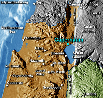
                        (Click on map to enlarge) – Once again, notice Capernaum. That served as Jesus’ home base for three years. On the map, notice Nazareth, where Jesus grew up. Also notice Cana, the location of Jesus’ first miracle. Notice Mt. Carmel, where Elijah fought the prophets of Baal. And finally, notice Caesarea Philippi, where Peter made his famous proclamation, “You are the Christ, the Son of the living God.”

                  • Read Matthew 8:6-15.
                      • Notice Peter’s house.
                      • Photo 13 - Peter's House - before church

                        (Click on photo to enlarge) – This is an old photo from the town of Nazareth. What you see here is a 5th century Byzantine church, which was built on top of a fourth century church house, which was built on top of a building from the 2nd century. This is the likely location of Peter’s house. In early centuries, church leaders would build on top of famous locations.

                      • Notice Peter’s house today.
                      • Photo 14 - Peter's House

                        (Click on photo to enlarge) – The reason I showed you the previous photo is because this is the current view of Peter’s house. A strange looking church has been built over Peter’s house. Yes, it does look like some type of spaceship from a sci-fi movie.

                  • Read Matthew :16-24.
                      • Notice the Sea of Galilee.
                      • Photo 15 - Sea of Galilee
                          Photo 16 - Sea of Galilee

                          (Click on photo to enlarge) – Storms can come up quickly on the Sea of Galilee because of mountains that near the northwest side of the Sea of Galilee. We will explain this when on the Sea next month.

                    • Read Matthew 8:25-28.
                        • Notice the towns.
                        • Map 10 - Sea of Galilee

                          (Click on map to enlarge) – This is the location where the next story will occur and Matthew 9:1 says he went back to his hometown.

                      Chapter 9

                    • Read Matthew 9:1-18.
                        • Notice the synagogues.
                        • Photo 01 - Capernaum
                            Photo 17 - Capernaum Synogogue

                            (Click on photo to enlarge) – Jesus often was in conflict with religious leaders of his day. I always imagined they were from Jerusalem, but many towns had synagogues and therefore, their own religious leaders. These two photos are of the synagogue. It is not the synagogue of Jesus, but it certainly is built on the foundation of the synagogue Jesus would have attended.

                      • Read Matthew 9:19-38.
                          • Notice the region around the Sea of Galilee.
                          • Map 11 - Sea of Galilee Towns

                            (Click on map to enlarge) – This section speaks of the news of Jesus spreading throughout the region, then Jesus going throughout the region teaching and healing. These are some of the towns Jesus was known to have visited.

                          • Notice Magdala.
                          • Photo 18 - Magdala

                            (Click on photo to enlarge) – This is an amazing recent find. It is the first century synagogue from the town of Magdala (where Mary Magdalene was from). Matthew 9:35 tells us Jesus taught in various synagogues. Certainly this was one of those places where Jesus taught.


                      • Day 2: Matthew 4-6

                        Here are step-by-step instructions for reading. I want to familiarize you with some geography as you read. It will help you next month when we are in these cities, towns and regions. If you are also using a study Bible – feel free to follow my instructions as you read the Study Bible and read the Study Bible notes.

                        Chapter 4

                      • Read Matthew 4:1.
                          • Verse 1 – Notice the desert where Jesus was tempted.
                          • Map 2

                            (Click on map to enlarge) – Chapter 3 ended with Jesus’ baptism. Find Jericho. Then look to the east from Jericho until you see the Jordan River. That is the likely site that John the Baptist baptized Jesus. In verse 1, Jesus leaves to go to the desert to be tempted.

                          • Notice the colored lines.
                          • Map 06

                            (Click on map to enlarge) – This shows the likely pathway (salmon-colored arrow) of Jesus from Galilee to be baptized (3:13), and then his journey to the traditional place of his temptation (the light blue arrow). When we are in Israel, there are many places we know for sure. Other places are “traditional” in nature based on decent evidence. And others we simply don’t know where they occurred. Our guide will help us know the certainty of various locations. Certainty comes from a few factors. Archeological evidence is primary. But also how early in church history a location was named as “the” location. Because of the strength of oral communication before the printing press – even one or two hundred years of separation between an event and identifying the location is not a long period of time.

                          • Notice the Judean desert.
                          • Photo 02 - Judean Desert
                              Photo 03 - Judean Desert

                              (Click on photos to enlarge) – Those are photos of the Judean desert/wilderness. It gives you an idea of the environment in which Jesus was tempted for 40 days and 40 nights.

                        • Read Matthew 4:2-11.
                            • Consider the map and photos above as you read.
                        • Read Matthew 4:12-13.
                            • Notice northern Israel.
                            • Map 02

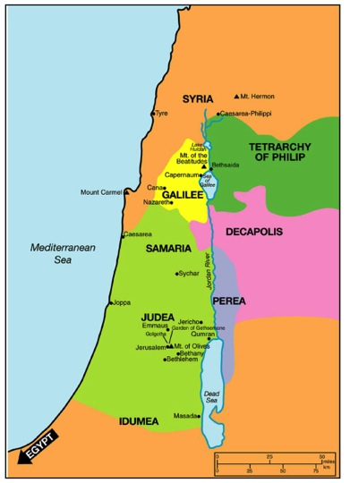
                              (Click on photo to enlarge) – Several locations are listed here. Notice Galilee is a region of northern Israel (near the Sea of Galilee). Also notice the town of Nazareth (where Jesus grew up) and Capernaum (which became his “home base” during his three-years of ministry.) Take note of how far Capernaum is from Jerusalem. Perhaps you didn’t realize how little time Jesus spent in Jerusalem. He would travel there for required worship feasts, but most of his time was spent in the Galilee region. We tend to assume he was in Jerusalem most of the time because of how many significant events in his life occurred there.

                            • Notice Zebulun and Naphtali
                            • Map 07 - Zebulun and Naphtali

                              (Click on map to enlarge) – Matthew says this is in the area of Zebulon and Naphtali (those are tribes of Israel). Notice this map to see those approximate regions.

                        • Read Matthew 4:14-22.
                            • Notice the Sea of Galilee
                            • Photo 04 - Sea of Galilee
                                Photo 05 - Sea of Galilee

                                (Click on photos to enlarge) – Notice a couple of views of the Sea of Galilee. A majority of Jesus’ ministry happened on the shores of the Sea of Galilee.

                          • Read Matthew 4:23-25.
                              • Verse 24 – Notice Syria.
                              • Map 02

                                (Click on photos to enlarge)

                              • Verse 24 – Notice the Decapolis.
                              • Map 08

                                (Click on map to enlarge) – Decapolis means “ten cities”. Verse 25 contains locations where people came to Jesus from. Look at this map and identify those places.

                            Chapter 5

                          • Read Matthew 5:1-12.
                              • Notice the hill where Jesus delivered the Sermon on the Mount.
                              • Photo 09 - Sermon on the Mount

                                (Click on photo to enlarge) – This is the location traditionally believed to be the place of the Sermon on the Mount. It is very close to Capernaum. You can see a church building at the top of the hill (“the Church of the Beatitudes”). Have you ever wondered how Jesus could speak to thousands of people at a time with no sound system? Acoustical studies have been done of this area, and on a non-windy day with no cars on the road – a person can stand at the top of the hill and hear a speaker at the water’s edge. This would be a perfect location for Jesus to preach to thousands. This was identified as the location of the Sermon on the Mount well before any acoustical studies were done.

                              • Notice the Church of the Beatitudes.
                              • Photo 10 - Church of Beatitudes

                                (Click on photo to enlarge) – Let me tell you the thing most will like least about going to Israel. This is a church built on the top of the traditional Mount of Beatitudes (Matthew 5:1-12). Well-meaning Catholics have turned as many traditional locations of Jesus’ ministry into churches. Just accept it or it will drive you crazy. Most evangelical pilgrims want to see what Jesus would have seen – not a church built on top of where Jesus had been. Again, it will be a likely frustration you will have. But just accept it and move on. You will enjoy the trip more that way. The worst violations are the place of his birth, death and resurrection. Those will be a bit shocking for you. (Just giving you a fair warning.)

                          • Read Matthew 5:13-48.
                              • All of this section is from the Sermon on the Mount.

                            Chapter 6

                          • Read Matthew 6:1-34.
                              • All of this section is from the Sermon on the Mount.


                          • Day 1: Matthew 1-3

                            Here are step-by-step instructions for reading. I want to familiarize you with some geography as you read. It will help you next month when we are in these cities, towns and regions. If you are also using a study Bible – feel free to follow my instructions as you read the Study Bible and read the Study Bible notes.

                            Chapter 1

                              • Notice Jerusalem.
                              • Map 1 (Click map for higher resolution)

                                (Click on map to enlarge) – Just spend a minute getting an overview of the map.

                          • Read Matthew 1:1-17.
                              • Verse 11 – Notice Babylon
                              • Map 3

                                (Click on map to enlarge) – When the southern tribes were taken into captivity they went from Jerusalem and the surrounding area to Babylon. 70 years later, God brought them back to Jerusalem. Three times Babylon is mentioned (vv. 11, 12 and 17).

                          • Read Matthew 1:18-25
                              • Notice Bethlehem.
                              • Map 5

                                (Click on map to enlarge) – The salmon line is the likely path that Joseph and Mary took to Bethlehem. The light blue line would be the likely route that the magi took. Although from the east, the best travel route would require them to head north, then down through the country.

                            Chapter 2

                          • Read Matthew 2:1-6
                              • Verse 6 – Notice Bethlehem.
                              • Map 2

                                (Click on map to enlarge) – This is the region of Judea (or Judah) and notice again Bethlehem, as mentioned in verse 6.

                          • Read Matthew 2:7-13
                              • Notice the area of the Middle East.
                              • Map 4

                                (Click on map to enlarge) – This is the likely route from Bethlehem to Egypt, and then the route from Egypt to Nazareth.The reason we would think this is the route is we know what the main roads were at the time.

                          • Read Matthew 2:14-23
                              • Notice the regions.
                              • Map 2

                                (Click on map to enlarge) – Notice the region called “Galilee” and the town of Nazareth.

                              • Notice the route.
                              • Map 4

                                (Click on map to enlarge) – This is the likely route from Egypt to Nazareth.

                            Chapter 3

                          • Read Matthew 3:1
                              • Verse 1 – Notice the region called Judea or Judah.
                              • Map 2

                                (Click on map to enlarge)

                          • Read Matthew 3:2-6
                              • Verse 5 – Notice Jericho.
                              • Map 2

                                (Click on map to enlarge) – Look at Jericho then look to the east from Jericho until you see the Jordan River. That is the most likely place that John the Baptist baptized Jesus. There are theories that he did it up by the Sea of Galilee, but with the emphasis being on Jerusalem and other factors – I think it was east of Jericho where Jesus was baptized. Did you know one of those going on the trip will be baptized in the Jordan River? It will be awesome!

                          • Read Matthew 3:7-17